About the site
CATEGORY OF PROTECTION: Significant Landscape
YEAR OF PROTECTION: 1974
SURFACE AREA: 1 197,77 ha
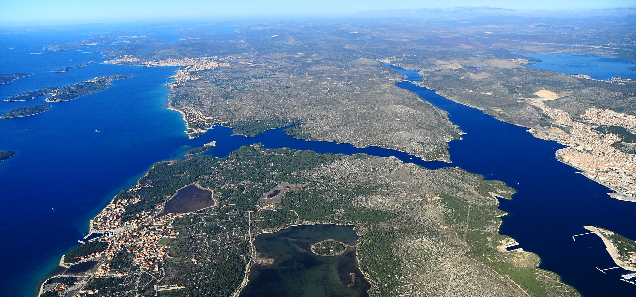
POSITION: Šibenik – from the Šibenik bridge to the fortress of St. Nicholas
Includes the area from the Šibenik bridge to the Channel of St. Ante, i.e. to the fortress of St. Nicholas, with the accompanying coastal regions. The area is divided into the Bay of Šibenik and the Channel of St. Ante. The Bay of Šibenik is further divided into Paklena, Martinska and Pećina-Zekovac. The border of the landscape passes through the middle of the bay parallel to the City of Šibenik. The channel begins with two capes, the northwestern Cape Burnji Turan and the southeastern Cape Južni Turan. The channel is a natural phenomenon, with numerous capes and coves. It is about 2500 m long, 140 to 220 m wide, and 42 m deep. The significant landscape includes several hills, the highest of which is Smričnjak (109 m), above Zekovac and the Njivice town quarter. Two rocky crags are found in the landscape, each with its own lighthouse. At the end of the channel is the Ročni crag and two islets (joined to the mainland by rock jetties): Školjić and Ljuljevac.
The main characteristic of the relief is karst. The oldest layers are Lower Jurassic and Middle Jurassic limestone. At the end of the Pliocene and early Pleistocene in the broader area of today’s Krka River, the erosional northern Dalmatian karst plateau was created, which extends over most of the catchment area of the Krka River basin. The canyon and mouth of the Krka River arose during the Pleistocene. The paleocanyon of the Krka River can be seen today along the southern coast of Zlarin Island. It is believed that in the past, the Krka River had a delta type mouth, unlike the estuary type mouth it has today, which arose as the result of the early Holocene post-glacial raising of the sea levels by 120 to 125 m about 18,000 years ago. The mouth of the Krk River, the Bay of Šibenik and Channel of St. Ante were formed in the Holocene (about 8500 years ago) and are part of the submerged mouth of the Krka River.
Sacral structure include the ruins of the Church of St. Martin (15th century) in the Martinska area, the Chapel of the Holy Cross on the right side of the Channel and just further down on the left side a cave that was built into the Church of St. Anthony (Ante) for which the first written mention dates back to the 13th century). It was in this cave church that the ascetics once lived, and among them Zadar noble Jeronim Detrico in the early 17th century. In the Jadrija area, we find the ruins of the Chapel of St. Andrew (Andrija).
At the end of the Channel of St. Ante, the remnants of two towers are still visible. From the 14th to the 16th century, a chain was pulled taught between them as the final line of defence of the city, to prevent hostile ships from entering into the Bay of Šibenik (harbour).
At the exit from the Channel of St. Ante, on the island of Ljuljevac, the walls of the fortress of St. Nicholas stand at the site of the destroyed Benedictine monastery of St. Nicholas (built in 1065).
The fortress was erected in the 16th century to protect Šibenik from the Turkish sea attacks. Construction of the fortress began in 1540, on the designs of Venetian military architect Gian Girolamo Sanmichelli, and was completed in 1540, though the structure was already in use in 1544. The lower sections of the fortress were built of white rock, while the upper section of bricks and travertine hauled from the Krka River. It was equipped to house 32 cannons and was amongst the grandest maritime fortresses along the eastern Adriatic coast. With its appearance and size, even the strongest enemies would hesitate before entering Šibenik from the sea.
St Nicholas’ Fortress is a unique part of the world cultural heritage under the protection of UNESCO.